
Throughout the period of Roman rule, the north-west was primarily a military region with complex roads and defences. Whilst the Romans’ initial conquest of Britain took place in 43 AD, the Lake District and Cumbria remained independent until 79 AD. However, even though Cumbria was occupied later than other parts of England, it still resulted in Roman influence which can be seen throughout Britain, as many Roman artefacts and former inhabited locations are in evidence around the Lake District.


By 100 AD, the Romans ruled over Cumbria and had begun building and completing roads and settlements. The Romans chose Cumbria as the north was at the frontier of the Roman Empire and they needed new military bases to solidify their strength and hierarchical position within society. Although Cumbria’s economy boomed under Roman control for a long period of time, hardly any wealth was given to the locals of the area and people began to suffer. The Romans departed from Cumbria and the Lake District in around 406 AD, which left town life suffering; many locations had been abandoned as they were no longer serving the functions they once had, with only a small population remaining in former Roman towns.
The town of Maryport is widely regarded as a key location of the Roman Empire in Britain, being the site of a large Roman fort which it is believed the Romans named ‘Alauna’. Alauna is one of the most common names in ancient Britain. Seemingly an adjective that served primarily as a name for a river, then commonly applied to forts and settlements near the mouth of a river, it could also be used for the names of local gods and people. It is possible that the Romans chose this name due to the location of Maryport, perhaps suggesting that the town was considered beautiful and wonderful, as it fulfilled both military and landscape needs.
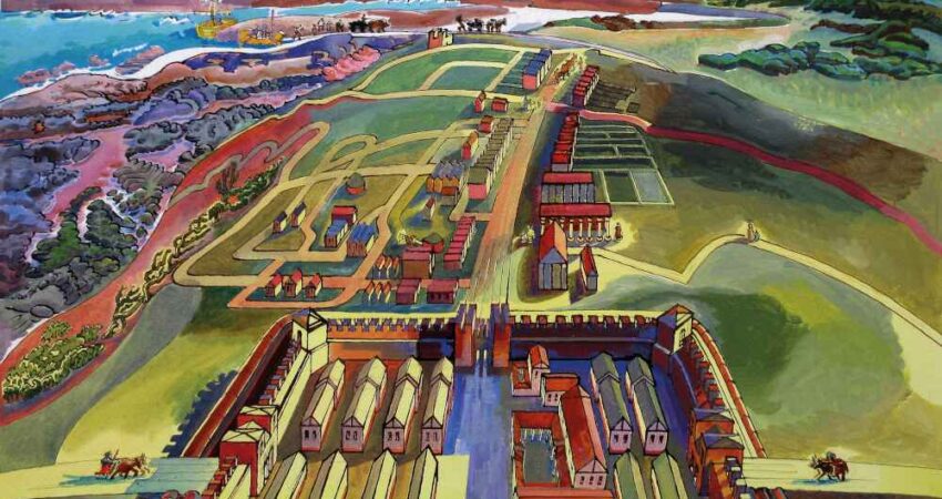
The Roman Empire was strategic in using both land and sea to defend, fight and transport goods, & whilst the section of Hadrian’s Wall between Bowness-on-Solway & Newcastle is the most well-known, the frontier did not end there. In the second century AD, on the orders of the Emperor Hadrian, following his tour of the province, the Roman army built a large fort at the top of the cliffs on the north eastern side of Maryport, replacing an earlier fort built on the site, discovered during an archaeological dig, partly adjacent to & partly under the later remains. The earlier fort is believed to be contemporary with the earliest fort built at Carlisle. Constructed of turf & timber, it was a so called ‘conquest’ fort, built quickly & used for establishing a base in a new territory. The site chosen took advantage of the strategic position overlooking the Irish Sea & the Solway Firth, strategically close to Hadrian’s Wall and the seafront forts. The later stone fort was begun around 122 AD & the creation of the sea fort meant that forts and sea mechanics could work in collaboration. The fort was larger than other forts on the coast, which leads historians to believe that it was the central fort for the western sea defences.
The geography of Cumbria shows that Maryport is the first site on the coast south of Hadrian’s wall with sufficient elevation to command a view over the Solway both north & south. A fault line, known as the ‘Maryport Fault’ runs through the area & this has produced a ridge of sandstone, (St Bees sandstone), which runs from Maryport up towards Carlisle. The River Ellen tends to follow the line of the Maryport fault. Being surrounded by a river, the sea & a narrow channel from Bank End to Netherhall, it was almost like an island, protected on all sides & readily defendable. This elevated site for the Roman fort was ideal, & with the sandstone being an aquifer, the site facilitated wells being dug through the sandstone to an outlet at the top of the hill.
With the construction of the Maryport fort, the Roman Empire dominated the area, with strong forts, Hadrian’s Wall & sea forts. The fort in Maryport covered some 6.5 acres and had the capacity to house 1,000 soldiers. The location of the fort led to it becoming the commanding headquarters and supply base for a chain of mile fortlets and watch towers, (extending from Hadrian’s Wall), as well as Hadrian’s Wall itself & the Roman legions at Cockermouth, (Papcastle), & in the Lake District.
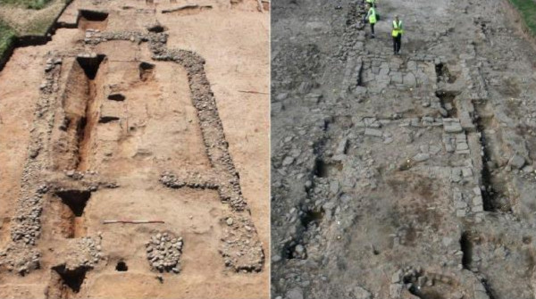
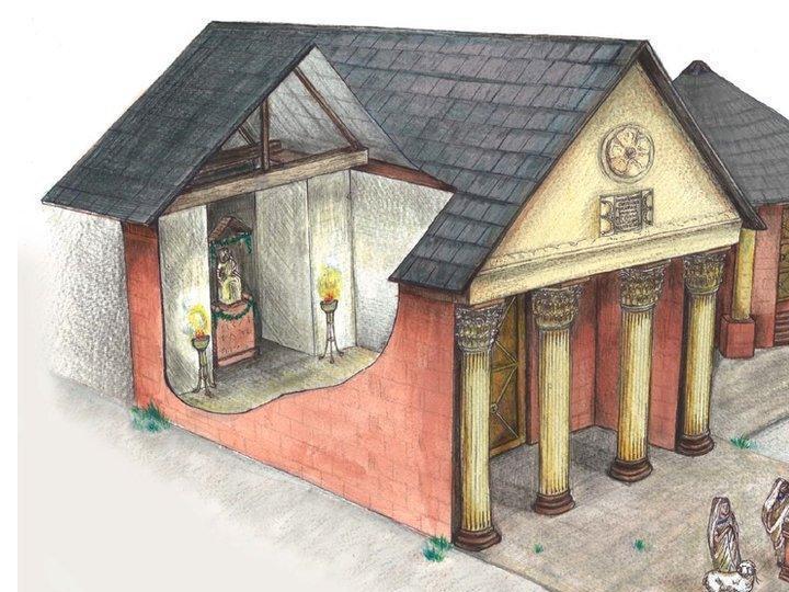
Geo-magnetic surveys have revealed the large Roman town to the north east of the fort. Historians believe the town was a living area for the Romans, their families & local trades people. Excavation has revealed rows of houses, shops & workshops along a main street & a classic Roman temple, the most northerly known example of such a temple. The temple was originally discovered by archaeologist Joseph Robinson in 1880, estimated to be about 8.4 metres tall, including an adjacent circular structure. Historians think that the temple would have been built specifically for the garrison, but was later also used by the non-military community. The extent & complexity of the extramural settlement was revealed by a TimeScape survey undertaken between 2000 & 2004, which identified a series of plots, apparently containing strip buildings, & ran for around 350 metres north eastwards. Two further surveys carried out by TimeScape & Southampton University between 2011 & 2015, the ‘Roman Temples Project’, & subsequent excavations by Oxford Archaeology North between 2013 & 2014 provided further information.
The Roman Temples Project focussed on an examination of seventeen altars discovered in 1870 in pits at the highest point of the Maryport landscape & mostly dedicated to Jupiter Optimus Maximus, dating to the second century AD. The remarkable collection of altars once associated with the temple is the largest group of military altar stones and inscriptions from any site in Britain, & reveals the careers of several officers who commanded the regiment at different times. The garrisons & their commanding officers came from as far away as Spain, Germany, Italy, Provence, (southern France), Noricum, (Austria), Croatia & North Africa. Maryport was an important military posting for them & they would have commanded the fort for three to four years before moving on to senior commands elsewhere in Europe. The extent of connections across the Roman Empire was further identified through the discovery of amphorae, ornaments & pottery, including fragments of tableware imported from Gaul and the Rhineland, storage vessels that once contained Spanish olive oil and Gallic wines, fragments of glass vessels and several items of jewellery including a jet finger-ring and part of a decorated glass bangle.
The Oxford Archaeology North excavation between 2013 & 2014 sought to develop the findings of the earlier TimeScape survey, seeking to discover more about the appearance & chronological development of the town’s buildings. The Oxford Archaeology North team found what was believed to be evidence of a road leading to a harbour to the north of the site. The idea of a harbour in the Bank End area is logical, as the shape of the coastline would have given some protection against gales & if there was more of an inlet, as seems likely in Roman times, it would make an ideal site for a harbour. Moving goods up to the fort & settlement would be easier as the incline is less than the southern slope. The site would also be suitable for moving goods inland to Papcastle or to Birkby & onto Carlisle & Hadrian’s wall.
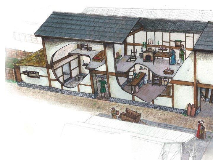
The Oxford Archaeology North team selected four parts of the settlement for further investigation. All four revealed structural remains around 30cm below the surface & one entire Roman building of a strip design measuring about 20m by 5m & encompassing three main rooms, believed to have been occupied for between 200 & 300 years. The team believed that the inhabitants would have been a mix of local people and people from other parts of the Roman Empire, including serving and retired Roman soldiers and those making a living at the settlement, with the possibility that the front room was used as a shop.
Despite the use of the fort & civilian settlement as a source of building stone from the 14th century to build Netherhall, the residence of local landowners the Senhouse family, the ruins were still visible in the 18th century. However, the remaining stones from the fort and settlement were used to build the town of Maryport in the 18th century, and sadly, by 1749, all standing remains had disappeared. Even though no remains were preserved, the Roman site still bore many inscriptions and altars.
In the 1570s, the Senhouse family started a collection of these Roman artefacts and set them within the walls of Netherhall. The unique examples of the seventeen Roman military altars found buried are extremely valuable to modern day understanding of the Roman period within Cumbria and are of international importance, believed to be the largest single find of Roman inscriptions ever found in Britain. They are now displayed in the Senhouse Roman Museum in Maryport, located next to the site of the former fort, on the hill to the north east of Maryport overlooking the town.
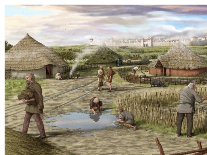
Artist’s Impression of Maryport’s Roman Fort & Settlement
The settlement is believed to have been divided into a series of long plots which extended along a 1,378ft, (420m,) length of Roman road leading to the fort gate.
Artist’s Impression of Maryport Roman Temple
Artist’s Impression of Roman Strip Building
Artist’s Impression of Maryport’s Roman Settlement
Image source, Hadrian’s Wall Trust
It is thought that the inhabitants would have been a mix of local people and people from other parts of the Roman Empire, including serving and retired Roman soldiers.
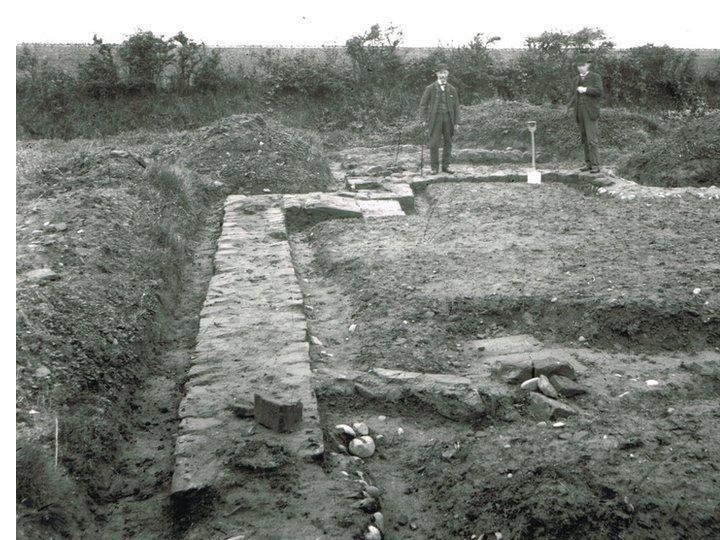
Image source, Senhouse Roman Museum
In 1880 archaeologist Joseph Robinson unearthed the remains of a Roman temple from the Second Century AD.
Roman Occupation of Britain
The Roman Empire was the most extensive political & social structure in western civilisation, beginning in 27 BC & lasting for over 500 years until its fall in 476 AD. Whilst the Roman occupation of Britain lasted from 43 AD to 410 AD, it was precluded by earlier reconnaissance. During Julius Caesar’s military campaigns in Gaul between 58 and 50 BC, he mounted two expeditions to Britain. The first, in 55 BC, was simply an armed reconnaissance, but the second in 54 BC was a serious attack that subdued the major tribes in south-eastern Britain. The Romans didn’t stay, but several tribes may have become friendly ‘client states’, in some respects still independent but also subordinate to Rome.
For almost a century afterwards, tribal rulers in southern Britain maintained diplomatic relations with Rome and traded across the English Channel with its provinces. However, during the first 40 years of the 1st century AD, the Catuvellauni tribe, based to the north and east of London, gradually gained power over neighbouring tribes, the Trinovantes and the Atrebates. This gave them control of territory further south, and also forced the expulsion from Britain in 42 AD of Verica, the pro-Roman king of the Atrebates.
The Catuvellauni’s growing anti-Roman stance coincided with the Emperor Claudius’s desperate need to consolidate his fragile hold on power. The usual way for emperors to shore up support was by military victory. So, the invasion of Britain was planned, with the treatment of Verica and the Atrebates as the pretext. Claudius sent an army in AD 43.
The Roman army landed at Richborough in Kent & rapidly established control. By 47 AD, it controlled most of the south & east of England, with a broad frontier stretching from Exeter to the Humber. Progress was held up by a rebellion in East Anglia led by Boudica, the Queen of the Iceni tribe, & whilst this was temporary, the Iceni tribe burned down three Roman towns at Colchester, (Carnulodunum), St Albans, (Verulamium) & London, (Londinium).
The Roman advance resumed around 70 AD, when the conquest of Wales and northern England began. The Roman governor Gnaeus Julius Agricola advanced his army up into Scotland as far as Aberdeen on the East coast, and defeated Caledonian tribes in battle at Mons Graupius in north-eastern Scotland in 83 AD.
However, this victory was short-lived. Troops were withdrawn to deal with trouble on the Danube frontier, and the army, struggling to hold the far north of Britain, (Britannia), gradually fell back. By around 105 AD, a new border zone along an east–west road, the Stanegate, between the River Tyne in the east and the Solway Firth in the west had been established. At this time, there were permanent bases for three legions, (heavily armed infantry units of 4,800 men), of Roman citizens at Caerleon, (in South Wales), Chester and York. Auxiliary troops, (smaller regiments of infantry and cavalry, raised from non-citizens in the provinces), garrisoned a network of smaller forts, mostly across northern England.
It was just a little further north of the Stanegate that the Emperor Hadrian, visiting Britain in 122 AD, ordered the building of a wall stretching from east to west, as a permanent frontier to Britannia. Hadrian’s Wall, as it came to be known, took some eight years to construct. Within a short time, the Emperor Antoninus Pius advanced north again, and from around 142 AD built another wall on the Forth/Clyde isthmus, known as the Antonine Wall. This wall, however, had only a short life, being gradually abandoned between 158 AD and 164 AD.
Although there were later military campaigns in the far north, including a huge campaign by the Emperor Septimius Severus between 208 & 211 AD, penetrating beyond the Antonine Wall, territory was not permanently conquered and Hadrian’s Wall remained the effective imperial frontier.
In the far west, Wales & most of the north, everyday life was much influenced by the presence of the Roman army, whereas in other areas, urban civilisation was more developed. There was never a mass immigration of ‘Romans’, rather, the people living in Britain were largely descendants of pre-Roman tribes who lived mainly in the countryside, overseen by Roman officials, whilst troops were generally recruited from provinces across the empire. It is likely that there would have been a gradual merging of people & culture in & around the towns & forts, but less so in the countryside. The army would have numbered around 50,000 out of a population of between 3 & 4 million.
The Roman economy in Britain was focused on towns, where a new urban governing class was created, composed of the former tribal rulers and their descendants. The province was divided into large administrative areas, or ‘civitates’, based on the tribal territories, each of which had a town capital. These towns were planned and built along Roman lines. Their ruling councils promoted a Roman lifestyle, erected typical Roman buildings, and governed the towns as centres of trade, manufacture, distribution and taxation. Between around 70 AD and the later 2nd century, such towns generally grew and prospered.
In between the ‘civitas’ capitals, along the roads and at road junctions, were smaller towns, roadside settlements and industrial centres. Many of them grew more organically and lacked most of the typical Roman public buildings, though many had a ‘mansio’, an official guesthouse that provided accommodation and fresh means of travel for the imperial postal network. In the north and west, where settlement remained military, settlements outside forts sometimes grew to the size of small towns, but generally lacked urban trappings and sophistication.
The countryside remained as it had been before, filled with farms, but they were linked by tracks and lanes to the major roads, and their produce could be sold in the towns. Such farms were sometimes rebuilt and reorganised, while villas, Roman-style buildings of varying size, were a new feature of the countryside. The most elaborate had underfloor heating, bath-houses, mosaics and elaborately painted walls, and formed the centres of large rural estates. It was often members and descendants of the former tribal elites who lived in them. In the far north of England, where few villas were built, traditional farmsteads remained numerous and fitted into the intense Roman system of supply and taxation.
Throughout the province, life outside the main settlements was slow to change; people simply had new and more demanding masters. Most of the population were the rural poor who, together with slaves, did the bulk of the work, with the Roman economy depending on slaves, either from Britain or elsewhere in the empire.
The Romans operated a money-based economy, centred on towns. They needed to generate income to pay for the army, & so soon after the conquest, administrators began to exploit the agricultural & mineral wealth of the new province. In the north & west, the fort garrisons were responsible for facilitating tax collection & the exploitation of natural resources. British grain was an important food source for Roman armies, while animals, (cattle, pigs, sheep & chickens), were also important. Minerals, especially copper, iron, lead, silver & tin, were mined to produce tools, weapons & jewellery. Pottery production centres multiplied & the practice of building in stone led to the expansion of large-scale quarrying to produce bricks & tiles.
Although the Romans brought their official gods and goddesses, they were not at all prescriptive in religion. Indeed, soldiers from all over the empire brought their own deities and eastern mystery cults to Britain. These imported religions went hand in hand with indigenous deities, and where characteristics were shared, hybrid gods emerged. Worship took place in the towns and the countryside, at cult centres, small temples and open-air shrines. In 313 AD, the Emperor Constantine I recognised Christianity, which had previously been outlawed, as a legitimate religion. Christianity then became more widely adopted across the empire, including in Britain.
Between 196 and 197 AD, the governor of Britain, Clodius Albinus, led a major but ultimately unsuccessful revolt against the Emperor Septimus Severus, following which Britain was divided into two provinces, Britannia Superior & Britannia Inferior, each with its own administration, with the intent on dispersing power. In the following century, the Roman Empire endured a long period of turmoil, with raids from outside the borders & civil warfare. Britain was part of two breakaway mini-empires, each of which lasted for a decade or more: the Gallic Empire, (260 to 274 AD); & the empire of Carausius & Allectus, (286 to 296 AD). In 296 AD, the Emperor Constantius restored the British provinces to the Roman Empire, & when he died in 306 AD, after a campaign against the Picts in Scotland, his son, Constantine the Great, was proclaimed emperor in York.
The third century AD was a period of turbulence, with a slowdown in building & the enclosing of towns with defensive walls. By the fourth century AD, the empire had a systematic tax collection system in place in a four-province arrangement introduced by the Emperor Diocletian, which was needed to support the army in defending the frontiers from the likes of the Picts in Scotland, raiders from Ireland & seaborne Saxon raiders in the south, for which the army became more dispersed into smaller units for the defence of towns.
The early 4th century saw a return to some peace and prosperity, but whilst parts of the west and south west witnessed the building of a flurry of palatial villas, towns were not what they had been at their height in the 2nd century. Persistent trouble on Rome’s other frontiers and relentless taxation in Britain ensured that towns operated on a more practical basis, and began slowly to decline. With only a few exceptions, civic buildings were neglected, reused for other purposes or abandoned. Resources were largely directed into funding the army, with little left over to express civic pride. War in the 350’s AD in Persia and Germany resulted in the withdrawal of troops from Britain, while vast quantities of grain were exported to feed the army abroad. There was also trouble on the Hadrian’s Wall frontier from around 360 AD & widespread raiding by Saxons, Picts and other groups, sometimes referred to as the Great Conspiracy of 367 AD, when much of the province was in turmoil.
Under the emperor Valentinian, (364 to 375 AD), Hadrian’s Wall and other garrisons were strengthened. But despite this, confident new building had ceased in Britain by the 370’s AD. Subject to neglect by Roman emperors, generals based in Britain repeatedly attempted to usurp power, including Magnus Maximus, (383 to 388 AD), and Constantine III, (407 to 411 AD), and Britain was drained of its best troops. By 411 AD, formally separated from Roman imperial administration, without an army and lacking organised taxation, the provinces of Britain could not sustain themselves, and town life totally collapsed. Thereafter, the inhabitants of Britain were no longer part of the Roman Empire.
Contributors
Maryport Town Council is indebted to the following in providing the information on which this narrative has been based:
Jane Laskey, Senhouse Roman Museum
Mark Coulthard, Chartered Engineering Geologist, (Retired)*
Oxford Archaeology North
Isla Haddon, Netherhall School
*Mark Coulthard was born in Maryport & is a member of the London Geological Society & International Association of Engineering Geologists. He has a strong connection with Maryport through his family. His Great, Great, Great Grandfather on his maternal side, Thomas Mark, set up & owned the Tannery. Thomas Mark’s son Joseph Mark, a banker/draper & magistrate, owned what is now the Town Hall. His son, Richard, also a banker, paid for the stained-glass windows in memory of his mother. He was also treasurer of the Spire Committee during the building of Christ Church.